Finding Aids for the 1950 Census
Geographic Finding Aids
An enumeration district, as used by the Bureau of the Census, was an area that could be covered by a single enumerator (census taker) in one census period. Enumeration districts varied in size from several city blocks in densely populated urban areas to an entire county in sparsely populated rural areas.
Enumeration District Maps
Enumeration district maps show the boundaries and the numbers of the census enumeration districts, which were established to help administer and control data collection. Wards, precincts, incorporated areas, urban unincorporated areas, townships, census supervisors` districts, and congressional districts may also appear on some maps. The content of enumeration district maps vary greatly. The base maps were obtained locally and include postal route maps, General Land Office maps, soil survey maps, and maps produced by city, county, and state government offices as well as commercial printers. Census officials then drew the enumeration district boundaries and numbers on these base maps.
The 1950 Census enumeration district maps may be viewed using the National Archives Catalog at https://catalog.archives.gov/search?q=*:*&f.ancestorNaIds=821491&sort=naIdSort%20asc.
For example, here is a section from the 1950 Census Enumeration District Map for Delaware, Sussex County, ED 3-1 - ED 3-79
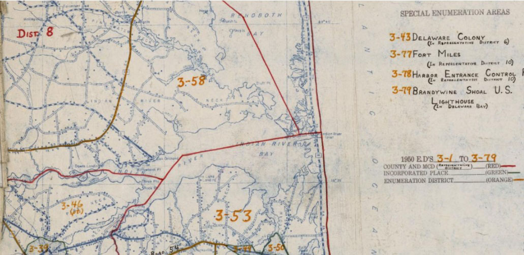
Section from 1950 Census Enumeration District Maps - Delaware (DE) - Sussex County - Sussex County - ED 3-1 to 79
-
Type in the search box the following: 1950 + the county + the state and then hit enter or click on the magnifying glass; for example: 1950 Sussex Delaware
-
You can narrow the search by including a town name in the search; for example: 1950 Milford Sussex Delaware
Note: Not all towns will have individual maps. You may need to look at county maps for some towns.
-
The search will bring back any matching results. The first three results will be listed, to see additional results click "View all Online Holdings."
-
Click the particular result you wish to see to view the larger version of the map.
-
You may use the zoom and pan features to enlarge the map and move the image on the screen.
-
If you have the address of an ancestor from 1950, find the address on the map and then look for the enumeration district number for that address. The map may have many other numbers on it. The ED number may be a two part number separated by a hyphen (in the red box below). The first number represents the county number and the second number the number of the enumeration district within that county.
Enumeration District Written Descriptions
The 1950 Census enumeration district descriptions may be viewed using the National Archives Catalog at https://catalog.archives.gov/search?q=*:*&f.ancestorNaIds=721175&sort=naIdSort%20asc
Type in the search box the following: 1950 + the county + the state and then hit enter or click on the magnifying glass; for example: 1950 Sussex Delaware
You can narrow the search by including a town name in the search; for example: 1950 Milford Sussex Delaware
In the search results, click on the title of the description to see the full description.
Stephen P. Morse's 1950 Search Engines:
Genealogist Stephen P. Morse has made available a number of useful search utilities for census and other records on his website, SteveMorse.org . Here are a few related to the 1950 Census:
- Unified 1870-1950 Census Enumeration District Finder
- Obtaining Streets within EDs for the 1870 to 1950 Census in One Step (Large Cities Street Finder)
- Viewing 1940-1950 Enumeration District Maps in One Step
- Viewing 1940-1950 Census Tracts in One Step
- Viewing 1940-1950 Wards, Tracts, and Block Maps in One Step
- Finding Transcribed ED Descriptions for 1880-1950 in One Step
- Viewing 1940/1950 ED Descriptions from T1224 Microfilm in One Step